
We offer different map tiles in raster and vector formats for the best interactive map experience. Our map tiles are compatible with all popular map rendering libraries and technologies, including Leaflet and MapLibre GL.
Every request have to be signed by an API key. For a detailed explanation click here.
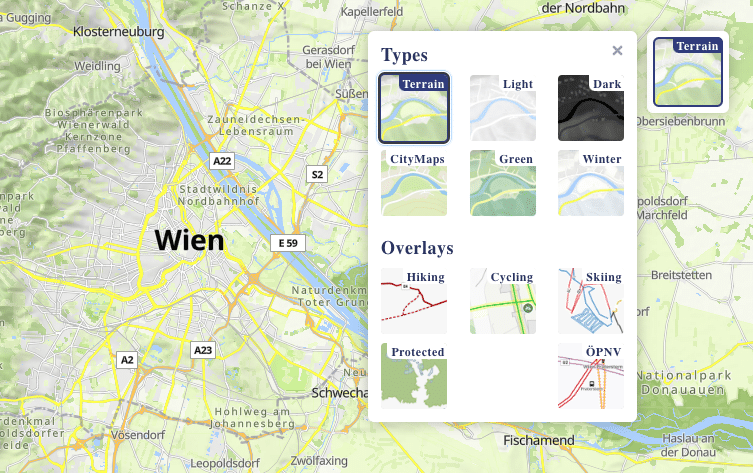
There a several default Maptoolkit map styles:
 terrain |
 terrainwinter |
 light |
 green |
 dark |
 city |
Please refer to our tile server examples for guidance on implementing the aforementioned map styles in Leaflet / MapLibre GL.
Please also check www.maptoolkit.com/map/ to see a working demo featuring a selection of our map styles. This showcase also incorporates predefined overlays that can be seamlessly integrated with our map styles.
You can use any of these map styles in a Leaflet/OpenLayers compatible environment.
A tile URL has the following format:
https://maptoolkit.p.rapidapi.com/tiles/{z}/{x}/{y}/{mapstyle}.png?rapidapi-key=your-api-key
For retina tiles use the &ratio=2 suffix.
https://maptoolkit.p.rapidapi.com/tiles/{z}/{x}/{y}/{mapstyle}.png?rapidapi-key=your-api-key&ratio=2
For custom map styles please get in contact.
You can use any of these map styles in MapLibre GL/Mapbox GL compatible environment.
A map style-URL has the following format:
https://static.maptoolkit.net/rapidapi/styles/{mapstyle}.json?rapidapi-key=your-api-key
contains a raster hill-shading layer, usable in vector maps. Maximum zoomlevel is 14.
https://maptoolkit.p.rapidapi.com/tiles/{z}/{x}/{y}/hillshading.png?rapidapi-key=your-api-key

contains terrain data encoded in png. Maximum zoomlevel is 14.
https://maptoolkit.p.rapidapi.com/tiles/{z}/{x}/{y}/terrain.webp?rapidapi-key=your-api-key

We employ a cutting-edge CDN to ensure swift and seamless delivery of our map tiles, minimizing any potential delays.